Z03
Data infrastructure and services
Prof. Dr.-Ing. Jan-Henrik Haunert
University of Bonn | +49 228 73-1750 |
Dr. Olaf Stein
Forschungszentrum Jülich | +49 2461 61-2370 |
Dr. Farzane Mohseni
University of Bonn | +49 228 73-20245 |
Dr. Amirhossein Nikfal
Forschungszentrum Jülich | +49 1782 980202 |
Summary
Project Z03 maintains a central research data infrastructure with open data services adhering to the FAIR data principles (findability, accessibility, interoperability, and reusability) hosted at Jülich Supercomputing Centre. It supports the research data management of all involved partners and the publication of their data. An integral part of the research data infrastructure is a set of services for data integration and aggregation, which enables analyses across data sets of different scales and heterogeneous quality, including HPC data workflows and management. A web-based visualization component complements the system to support users in data exploration tasks.
Contributors
Prof. Dr.-Ing. Jan-Henrik Haunert, University of Bonn
Dr. Olaf Stein, Forschungszentrum Jülich
Dr. Farzane Mohseni, University of Bonn
Dr. Amirhossein Nikfal, Forschungszentrum Jülich
Main tasks and results in 2023
- Developed and launched the DETECT-Geonetwork Data Portal, the core platform for CRC 1502 DETECT, to establish a centralized research data infrastructure.
- Collected requirements regarding metadata standards and technical needs from all subprojects. The metadata framework and 13 standardized keyword categories have been designed and finalized for consistent data organization.
- Focused on soil moisture data integration and development, as it is one of the most important datasets in the DETECT project.
Publication:
Mohseni, F., Ahrari, A., Haunert, J.-H., & Montzka, C. (2023). The synergies of SMAP enhanced and MODIS products in a random forest regression for estimating 1 km soil moisture over Africa using Google Earth Engine. Big Earth Data, 8(1), 33–57. https://doi.org/10.1080/20964471.2023.2257905
Main tasks and results in 2024
- Initiated collaboration with subprojects to align metadata and technical requirements.
- Organized bi-weekly workshops and produced tutorial videos to support data submission and use of the portal.
- Developed the first version of the map visualization system:
– Started with point-based validation data and expanded to polygon and raster data.
– Focused on Land Use and Land Cover (LULC) maps. - Setting up the ESGF data platform and search engine on Jülich servers (in progress).
Web-page links:
DETECT-Geonetwork data portal: https://detect-z03.geoinformation.net/
YouTube channel of tutorial videos : https://www.youtube.com/channel/UCHagJHg8J9rN9z_vKWfXe-Q
Data map application: https://detect-z03.geoinformation.net/map/
ESGF web interface (MetaGrid): https://esgf.jsc.fz-juelich.de/metagrid/
Publication:
Nikfal, A. and Karimi, M.A., 2024. Operational workflow to simulate biophysical variables, based on the coupled WRF/SEBAL models. Computers and electronics in agriculture, 222, p.109003. https://doi.org/10.1016/j.compag.2024.109003
Nikfal, A. 2025. “ WRFtailor: A Toolkit for Tailoring the WRF Model Input Data.” Geoscience Data Journal 12, no. 4: e70031. https://doi.org/10.1002/gdj3.70031
Plans for 2025
- Enhance map visualization tools for broader dataset integration.
- Extend support for new data types, including advanced geospatial layers.
- Further develop applications for LULC analysis.
Publication:
Mohseni, F., Rottman, P., & Haunert, J.-H. (2025). Multi-Criteria Optimization Approach for the Geometric Integration of Vector-Based Land Cover Datasets. International Journal of Digital Earth (https://doi.org/10.1080/17538947.2025.2562058)
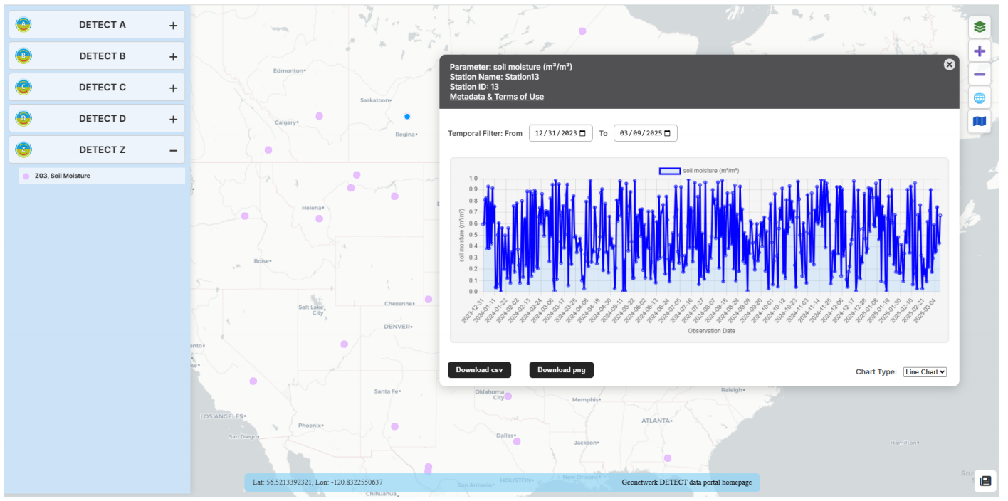
Figure 1: Visualization of time-series data for individual stations in the DETECT project.
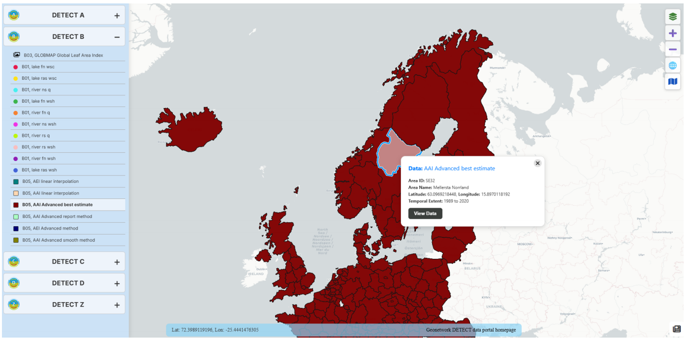
Figure 2: Display of polygon-based data on the map portal, linked to the GeoNetwork catalog for detailed metadata.
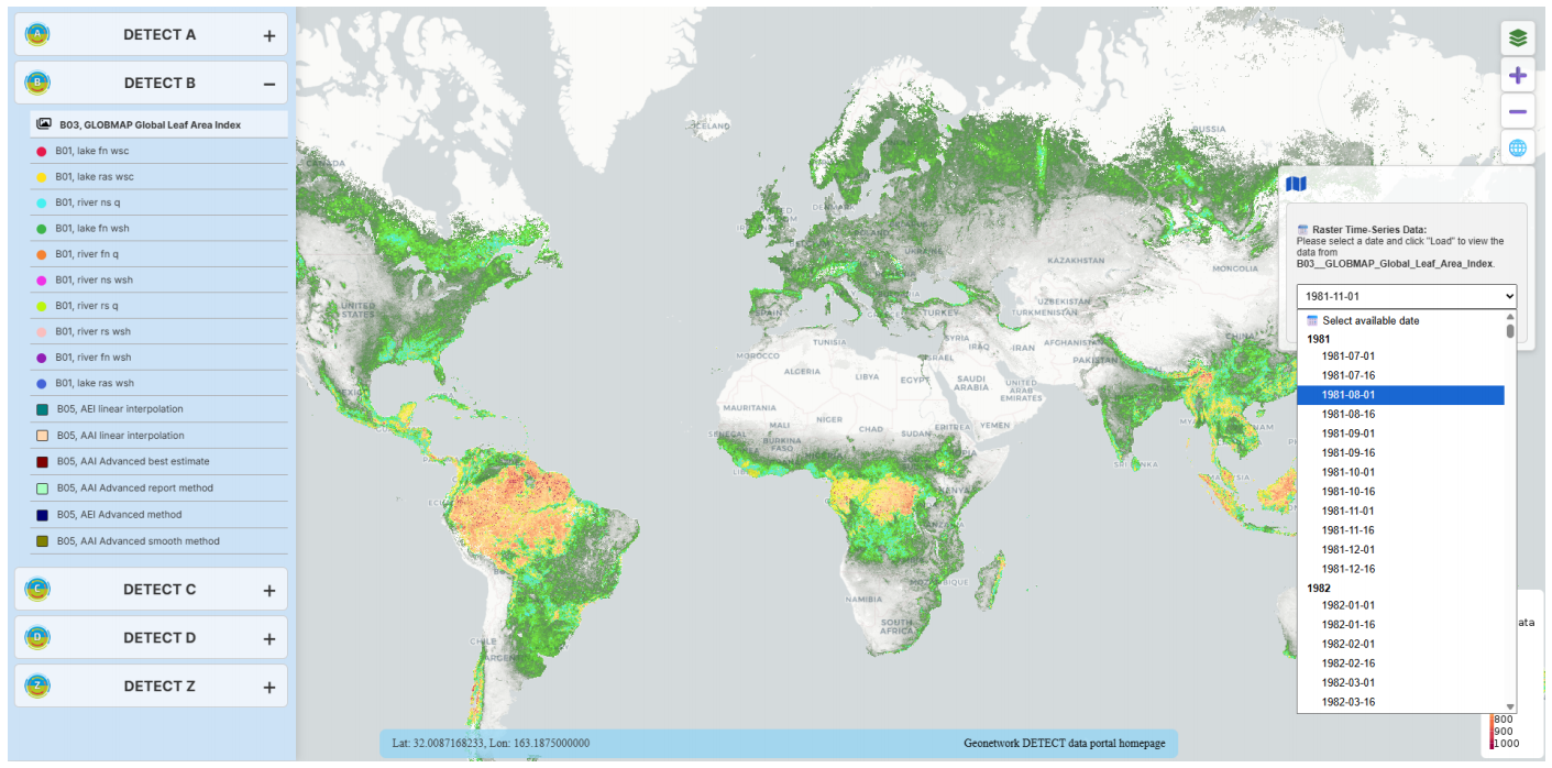
Figure 3: Hosting, sharing, and visualizing time-series raster datasets on the map portal.