D05
Deep generative networks for detecting anomalous events in the water cycle
Prof. Dr. Juergen Gall
University of Bonn | +49 228 73-69600 |
PD Dr. Petra Friederichs
University of Bonn | +49 228 73-5187 |
Anas Al-lahham (PhD student)
University of Bonn | +49 228 73-69600 |
Summary
Although there is a general expectation that extreme events in the water cycle are occurring more frequently and become stronger due to climate change, it remains a challenge to identify them in large simulation data sets. While extreme events can be defined based on impact indicators like agricultural droughts, these indicators do not cover all extreme events. We therefore aim to identify extreme events in simulated water cycle components by developing novel deep networks that detect anomalous events in simulated data.
Graphical summary

Fig. 1: Using data from simulations, the deep network detects anomalous events.
Contribution to the CRC
D05 addresses the central hypothesis of CRC by developing machine learning techniques to analyze simulation data focusing on detecting anomalous patterns in simulated variables.
Approach
For predicting extreme events such as agricultural droughts or wildfire, we will train deep neural network on TSMP data as well as remote sensing data. The deep networks will be first trained using full supervision, i.e., they will be trained by taking the generated data as input and minimizing the difference between the predicted and annotated extremes (e.g., wildfire or droughts). In a second step, we aim to train the networks unsupervised in order to identify anomalous events in simulated data.
Main Results in 2022
In collaboration with B03, we developed a deep learning approach that predicts when weather conditions have a high tendency to cause an extreme event such as large wildfire events.
M. H. Shams Eddin, R. Roscher and J. Gall, "Location-Aware Adaptive Normalization: A Deep Learning Approach for Wildfire Danger Forecasting," in IEEE Transactions on Geoscience and Remote Sensing, vol. 61, pp. 1-18, 2023, Art no. 4703018, doi: 10.1109/TGRS.2023.3285401.
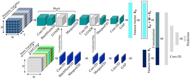
Fig. 2: We propose a convolutional neural network for wildfire danger forecasting that handles static and dynamic variables differently. Since the static variables do not change over time, they are processed by a branch consisting of 2D convolutions while the dynamic variables are processed by the second branch with 3D convolutions. To address the causal effect of static variables on dynamic variables, we introduce feature modulation for the dynamic variables (LOADE) where the modulation parameters are generated dynamically and conditionally on the geographical location.

Fig. 3: Qualitative results produced by the proposed approach. The black circles represent an ignition of a large wildfire on that day.
Main Results in 2023
We developed deep learning models (Focal-TSMP) to predict satellite-based vegetation products from a regional climate simulation. The simulation is produced by the Terrestrial Systems Modelling Platform (TSMP) and performed in a free evolution mode. TSMP simulations includes variables from underground to the top of the atmosphere (Ground to Atmosphere G2A). We used the simulation for long-term forecasting and deep learning to predict Normalized Difference Vegetation Index (NDVI) and Brightness Temperature (BT) maps from the forecast variables (Fig. 4). These predicted maps were then used to derive various vegetation health and agricultural drought indices like NDVI anomaly, BT anomaly, Vegetation Condition Index (VCI), Thermal Condition Index (TCI), and Vegetation Health Index (VHI). The primarily application of this study is to estimate satellite derived vegetation indices for periods when satellite observation are unavailable and to model climate change scenarios may affect vegetation responses to extreme events.
Shams Eddin, M. H. and Gall, J.: Focal-TSMP: deep learning for vegetation health prediction and agricultural drought assessment from a regional climate simulation, Geosci. Model Dev., 17, 2987–3023, https://doi.org/10.5194/gmd-17-2987-2024, 2024.
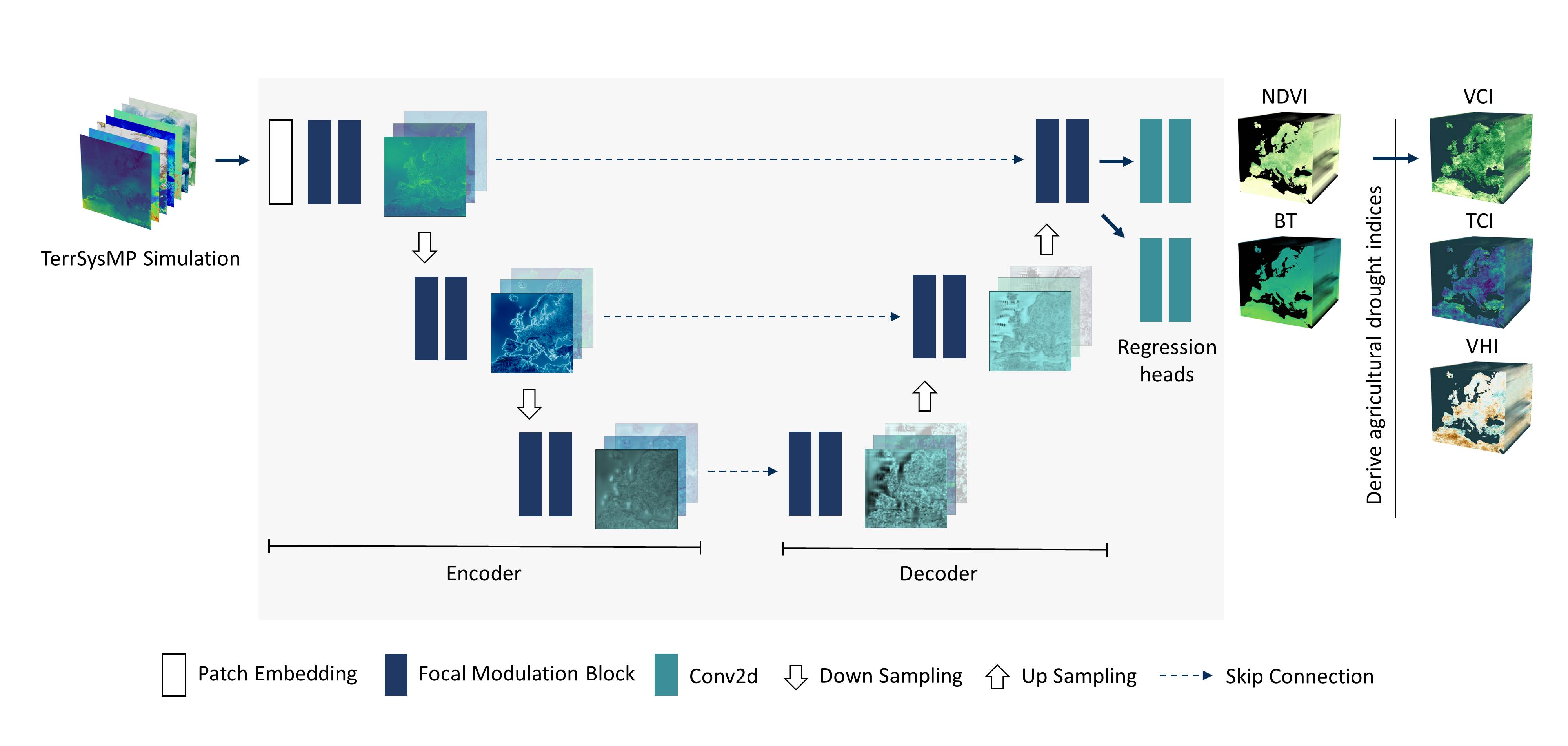
Fig. 4: The model design follows a U-Net architecture with focal modulation blocks. The input for deep learning is a data cube representing a specific week of TSMP data and the output are NDVI and BT corresponding to the same week. The predicted NDVI and BT are used to derive different agricultural drought indices.
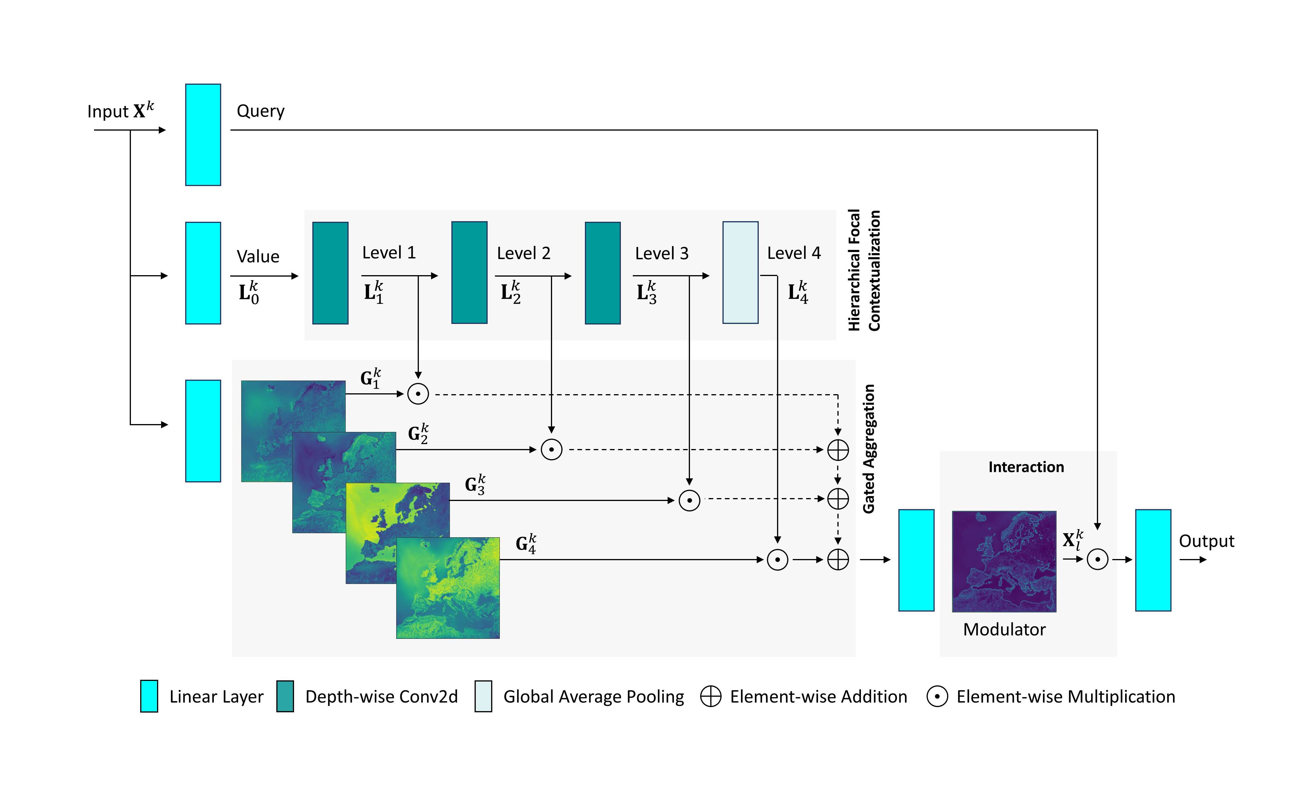
Fig. 5: An illustration of the Focal Modulation Block. It consists of 3 main components: focal contextualization, gated aggregation, and interaction. First, the input is projected with linear layers to obtain query and values gates. Then, contextual features are derived by a stack of depth-wise 2D convolutions. Gates are used to adjectivally aggregate extracted features into a modulator. Finally, the output is obtained by an interaction between the queried pixels and the modulator.
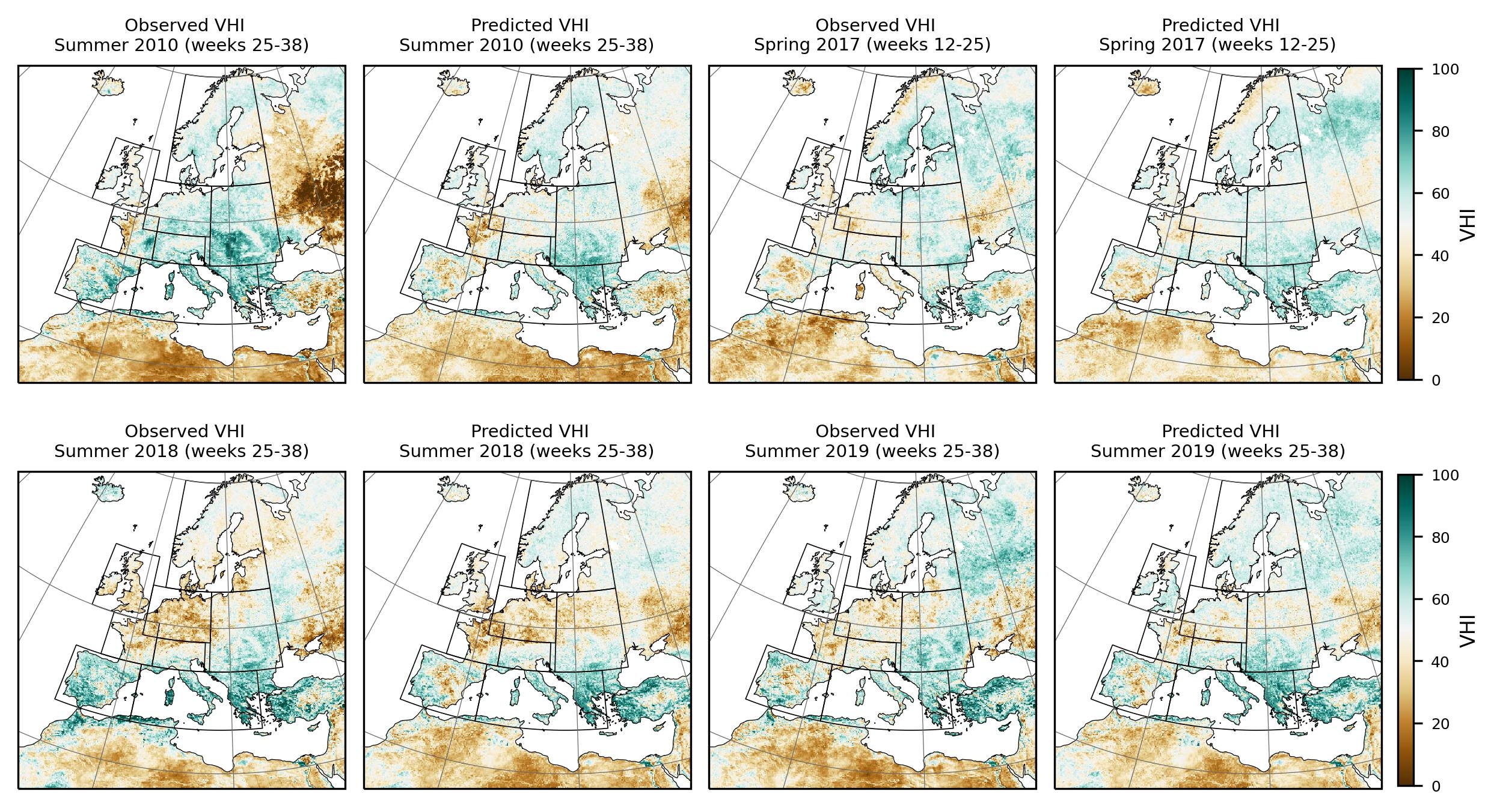
Fig. 6: Comparison between the seasonal predicted Vegetation Health Index (VHI) and NOAA observations over Pan-Europe domain.
Main Results in 2024
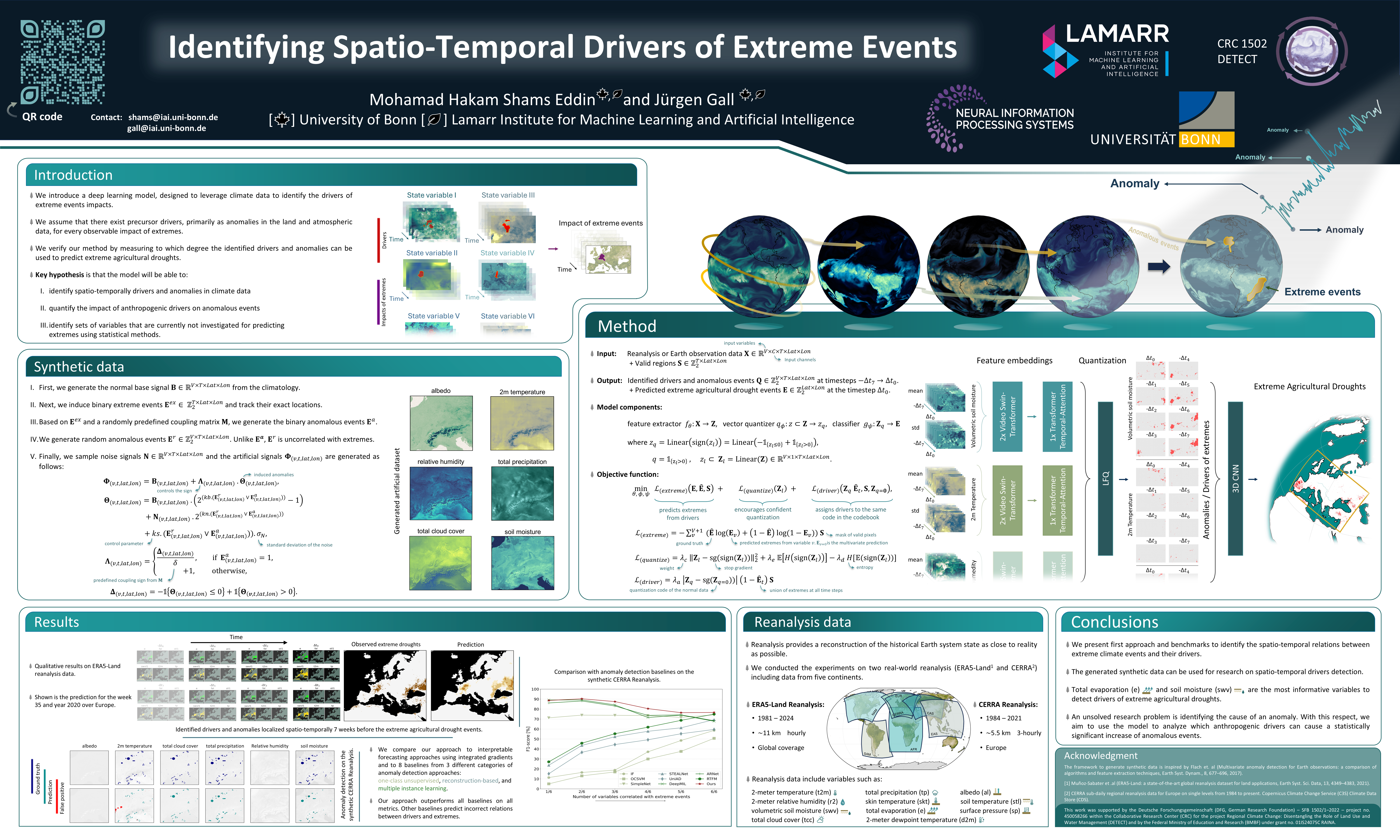
The spatio-temporal relations of extreme events impacts and their drivers in climate data are not fully understood and there is a need of machine learning approaches to identify such spatio-temporal relations from data. The task, however, is very challenging since there are time delays between extremes and their drivers, and the spatial response of such drivers is inhomogeneous. In this work, we propose a first approach and benchmarks to tackle this challenge. Our approach is trained end-to-end to predict spatio-temporally extremes and spatio-temporally drivers in the physical input variables jointly. We assume that there exist precursor drivers, primarily as anomalies in assimilated land surface and atmospheric data, for every observable impact of extremes. By enforcing the network to predict extremes from spatio-temporal binary masks of identified drivers, the network successfully identifies drivers that are correlated with extremes. We evaluate our approach on three newly created synthetic benchmarks where two of them are based on remote sensing or reanalysis climate data and on two real-world reanalysis datasets. Our code and models are available at: https://hakamshams.github.io/IDE
Shams Eddin, M.H. and Gall, J., Identifying Spatio-Temporal Drivers of Extreme Events. In The Thirty-eighth Annual Conference on Neural Information Processing Systems, https://openreview.net/forum?id=DdKdr4kqxh, 2024.
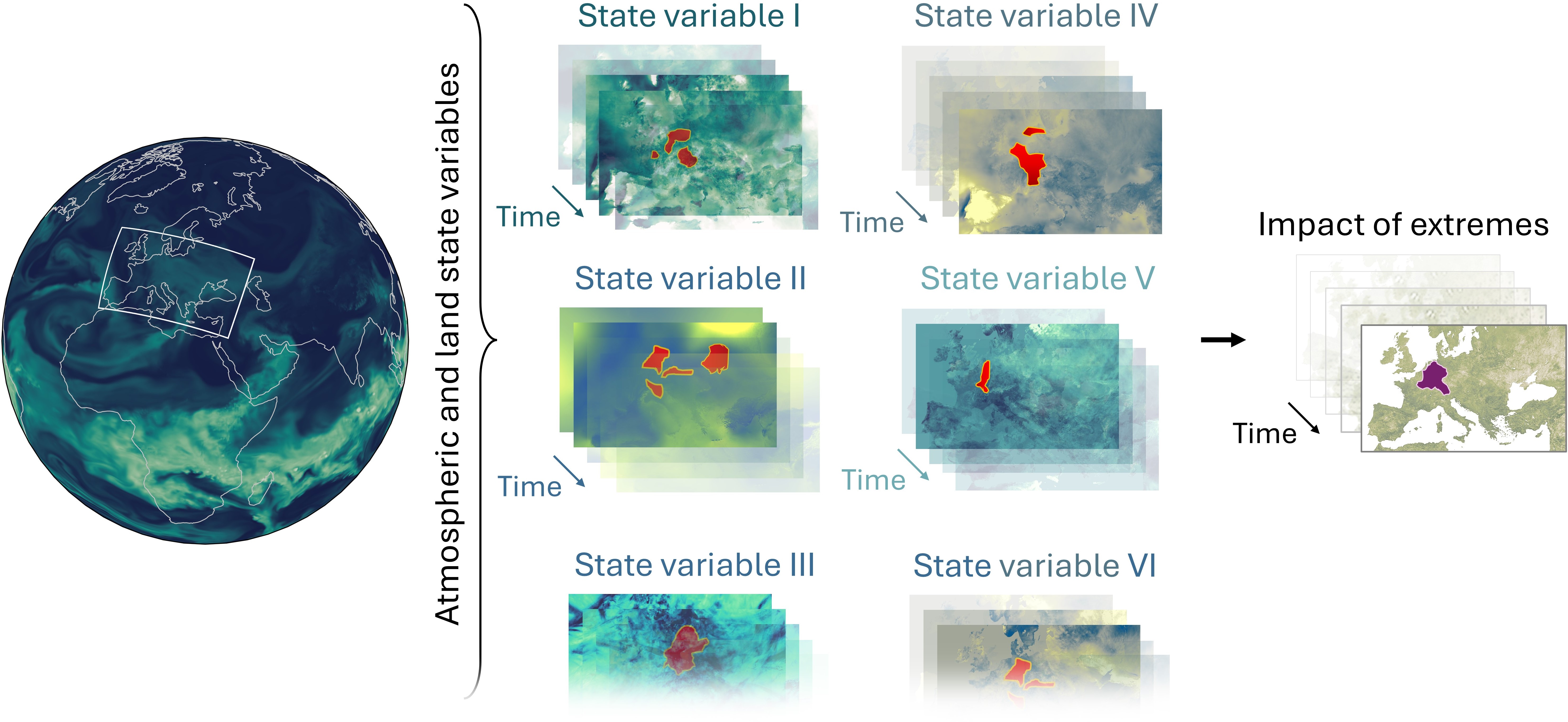
Fig. 7: Overview of the objective of this work. We are interested in identifying spatio-temporal relations between the measurable impacts of extremes like the vegetation health index and their drivers. As drivers, we focus on anomalies in state variables of the land-atmosphere and hydrological cycle. The task is very challenging since the drivers can occur at a different region than the extreme event and earlier in time.
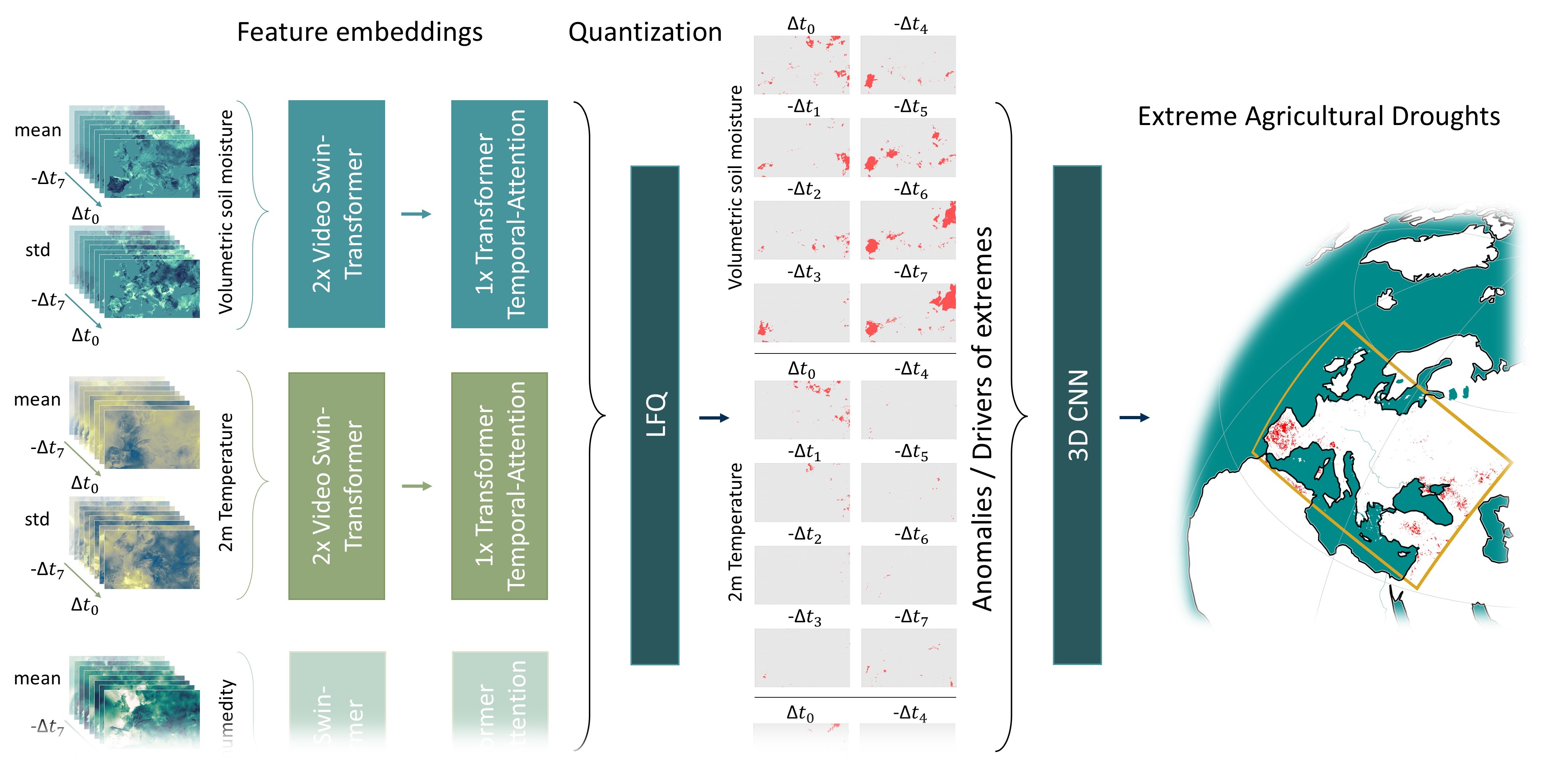
Fig. 8: An overview of the proposed model to identify the spatio-temporal relations between extreme agricultural droughts and their drivers. The input variables are first encoded into features. In a subsequent step, a lockup free quantization layer (LFQ) takes the extracted features and classifies the variables into a binary representation of drivers, where we consider the drivers as anomalous events in the input variables. Finally, a classifier is used to predict impacts of extreme events from the identified drivers.
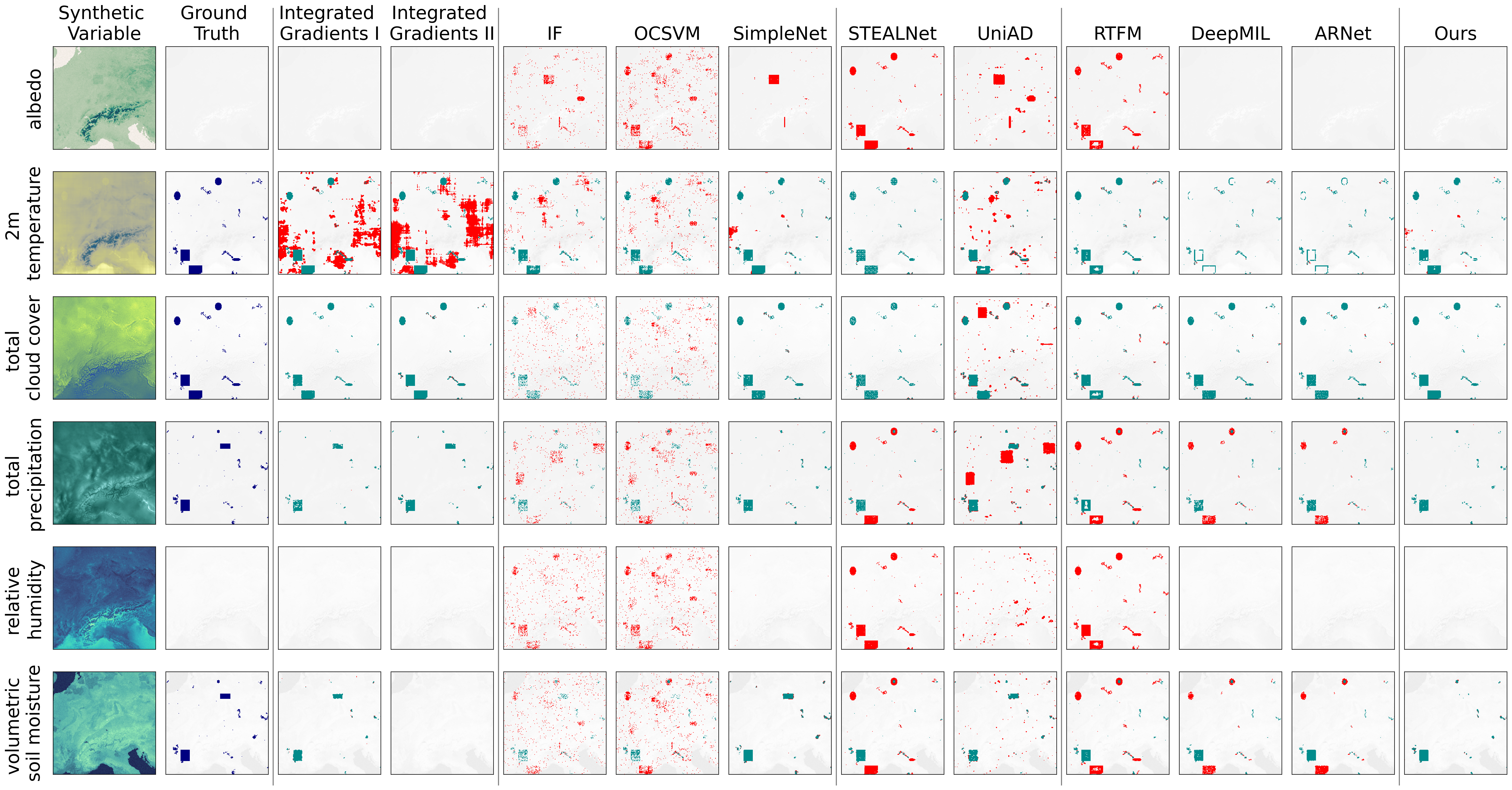 Fig. 9: Qualitative results on the synthetic CERRA reanalysis from the test set. Albedo and relative humidity are not correlated with extremes, meaning that they do not contain drivers, but only random anomalies.
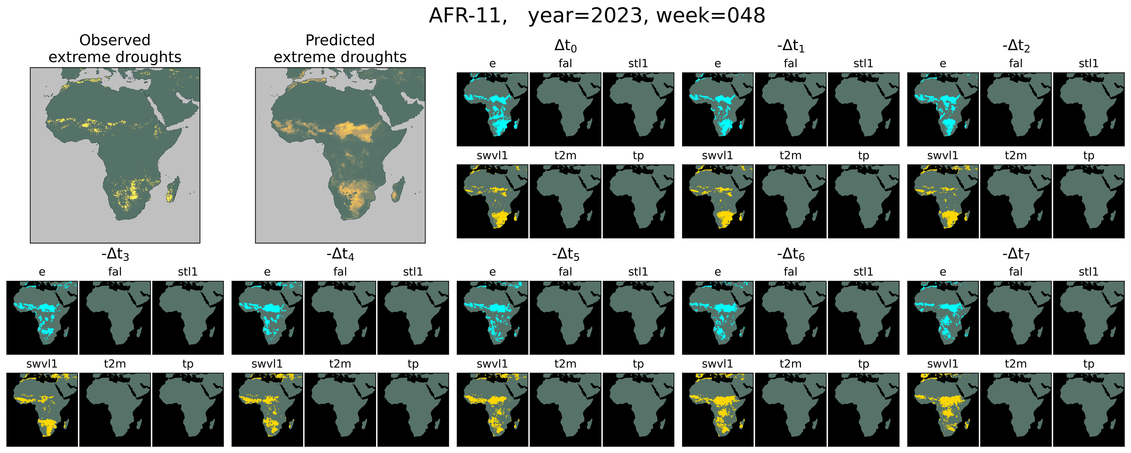
Fig. 10: Qualitative results on ERA5-Land for Africa (AFR-11). Shown are the identified drivers and anomalies for each variable along with the prediction of extreme agricultural droughts on the top left.
Patnala, A., Schultz, M. G., & Gall, J. (2025). BERT Bi-modal self-supervised learning for crop classification using Sentinel-2 and Planetscope. Frontiers in Remote Sensing, 6, 1555887.


