B01
Impact analysis of surface water level and discharge from the new generation altimetry observations
PD Dr.-Ing. L. Fenoglio
University of Bonn | +49 228 73-3575 |
Jiaming Chen (PhD student)
University of Bonn | +49 228 73-60567 |
Summary
Surface water level and river discharge are key observables of the water cycle and among the most sensible indicators that integrate long-term change within a river basin. The new generation of spaceborne altimeters includes Delay Doppler, laser and bistatic SAR altimeter techniques. The central hypothesis of B01 is that these new observations outperform conventional altimetry (CA) and in-situ measurements providing (a) surface water levels and discharge of higher accuracy and resolution (both spatial and temporal), (b) new additional parameters (river slope and width) and (c) better sampling for flood event detection and long-term evolution, providing valuable new information to the CRC.
Phase 1 addresses two research questions: „How can we fully exploit the new missions to derive water level, discharge, and hydrodynamic river processes“ and „Can we separate natural variability from human water use“?
For this, B01 monitors with space observations water height change and water exchange between rivers, lakes and reservoirs and the impact of natural and human disturbances. River discharge Q is the primary product of B01, that is made available in the CRC modelling and for assimilation in the IMS.
A multi-sensor database is built and used in the IMS, together with C- and D-projects. River discharge innovatively derived from SWOT measurements of river slope, height and width will enable us to validate these datasets and approach.
Graphical Summary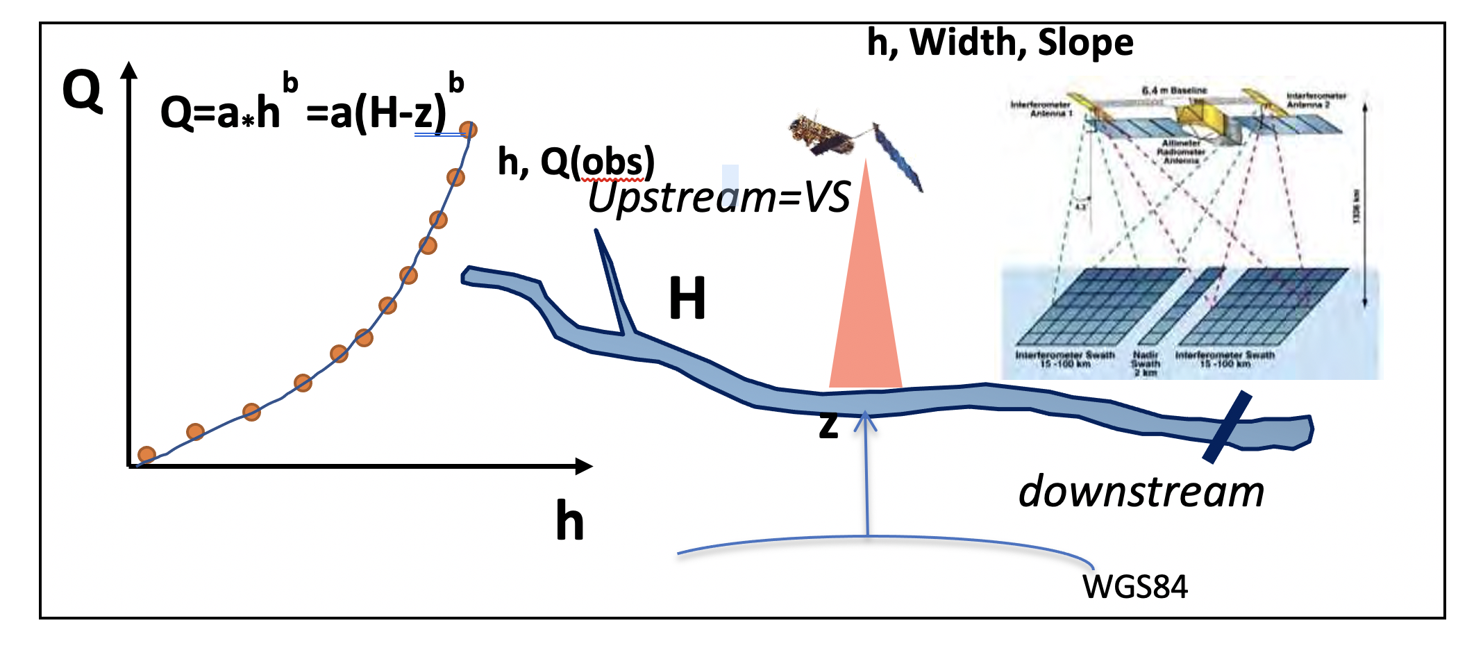
Figure 1. Graphical Summary of B01
Contribution to CRC
The project contributes to the CRC’s key objectives in that it addresses the surface water compartments with improved observations types to be included in the modelling. Our main contribution to the CRC is our expertise in Satellite Altimetry to derive water surface height and water surface extent from satellite techniques. Combining space techniques and in-situ data we derive river discharge and water storage change in time and we provide these two quantities to the CRC, together with their accuracy. Moreover, we prepare for assimilation of discharge data in the land model. We provide tempo-spatial observations of surface water and discharge changes, both indicators of climate change.
Main results in 2022
We have designed a processing scheme to derive water level heights at the intersection of the altimeter tracks with the river, the so called virtual gauges and to validate them with in-situ stations. We have analysed SAR altimetric data of the CryoSat-2, Sentinel-3 and Sentinel-6 missions produced by an Unfocused SAR processing. The validation against in-situ data shows a STDD smaller than 20 cm most virtual gauges (Figure 1). We have simulated SWOT data with the CNES hydrology simulator to experiment with data of the SWOT mission (Figure 2). Region of analysis is the river Rhine (ROI1).
Main results in 2023
We have extended an existing FF-SAR Processor to process all altimeter SAR mission. With dedicated processing we have increased the along-track resolution of the standard data and the quality of the data. The long computation time needed in FFSAR processing with the Back Projection algorithm has been reduced by 80% by implementing as second algorithm the omega-kappa algorithm. The radargram in FFSAR along the ROI is shown in Figure 4.
For the calibration and validation of the SWOT mission, eight GNSS-R instrumentations and 4 Vortex stations have been installed in the river Rhine between Mannheim and Andernach. We have derived discharge from space data in the ROI using simplified empirical hydrodynamic relationship. The validation of the SWOT data against the in-situ data has started, see Figures 5 and 6.
Figure 2. Time-series of water surface height at Virtual Gauge (VG) in Mainz (northern red point in Fig. 3) and STDD of differerence with Real Gauge (RG) in Mainz.
Figure 3. Time-series of water surface height at Virtual Gauge (VG) in Mainz (northern red point in Fig. 3) simulated in CNES hydrology simulator.
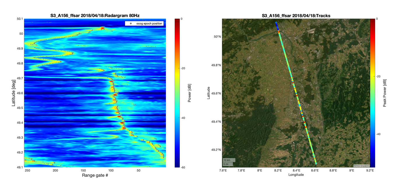
Figure 4. Sentinel-3A radargramm and along-track power.
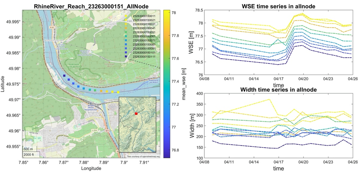
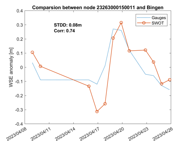
Figure 5. Preliminary results show a standard deviation of 8 cm between the SWOT node product and the gauge in Bingen over 20 days.
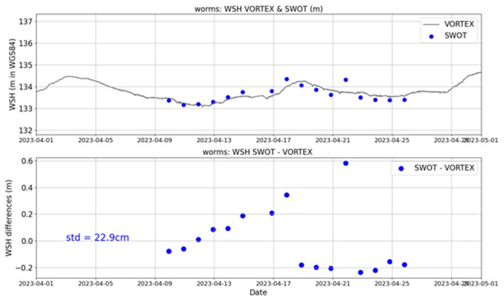
Figure 6. Preliminary results show a standard deviation of 23 cm between the SWOT pixel cloud product and the Vortex gauge in Worms over 20 days. Systematic errors will be reduced in the next SWOT data release.
Main results in 2024
We have validated in Central Europe the SWOT water level of the 1-day (cal/val) and of the 21-day science phase against in-situ and nadir-altimetry founding excellent data quality (Srinivasan et al., 2025, Fenoglio et al. in review). Also the derived products river discharge and water storage change have been validated (Fenoglio et al, 2025a, 2025b. 2025c in preparation). New with SWOT is the estimation the river discharge at any location along the river by combining the observations with simple law equations (Andreadis et al., 2025, Durand et al., 2023). The example in Fig. 7 compares the discharge from SWOT, from in-situ and from the Sobek hydrodynamic model in the reach that includes the station of Maxau, the statistics shows a NSE of 0.86 and a normalized bias (nBIAS) of 10%. New with SWOT is also the estimation of water storage change globally. Lake water surface area derived from Sentinel-1 and -2 using Google Earth Engine (GEE) was compared to lake water surface area of the SWOT raster data. Water storage change in lakes and reservoirs was finally derived combining area from GEE and water heights in Switzerland from SWOT and Sentinel-3/6 SAR altimetry. We find changes in water level of 1-2 meters in natural lakes and up to 60 m in hydropower reservoirs. SWOT observed 140 water bodies, a factor 10 more than the nadir-altimetry.
Fig 7: Estimation of discharge in Maxau (the Rhine River) during the SWOT cal/val phase. (top left) The SWOT observations of water height (orange), Sobek hydrodynamic model (violet) and in-situ data (red). (top right) River width from SWOT (blue) and Sobek hydrodynamic model (violet). (bottom left) River slope from SWOT. (bottom right) River discharge from SWOT. The SWOT water level, river width and slope are used as inputs to estimate river discharge, applying a simple flow law with pre-defined coefficients from Birklei et al. (2013).
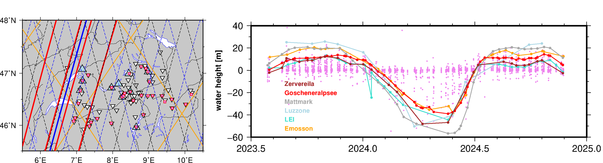
Fig. 8. (left) Reservoirs in Switzerland (white inverted triangles) larger than 0.5 km². Reservoirs observed by nadir altimetry (S3A and S3B) are marked with light blue triangles, while those observed by SWOT are marked with violet squares. (right) Water surface anomaly from the SWOT Science phase in both natural lakes and reservoirs form SWOT.
Main results in 2025
The discharge in rivers has been estimated by simple law in Fenoglio et al., 2025b, in preparation. Time-series are available fields for the interval 2016-2024 for a first set in Germany. The water storage change in lakes has been estimated combining surface area from Sentinel-1,2 and water height from nadir and SWOT altimetry. Fenoglio et al., 2025b, in preparation, gives first results for Switzerland. The estimated parameters water level, discharge, surface area and water storage change have been made available with a web interface at https://detect-z03.geoinformation.net/map/.
Further or, we have run the unconstrained Confluence Flow law parameter estimation (FLPE) algorithms MetroMan, Momma, NeoBAM, and SIC4Dvar with diffeerent choices compared to the official unconstrained Confluence DAWG run. We selected prior width larger than 30 m, prior length larger than 1000 m and validated unconstrained discharge estimates against European gauges, alongside an evaluation of the constrained output made available by DAWG at http://doi.org/10.5281/zenodo.14805617.
The number of gauge stations used for evaluating the unconstrained discharge estimates varies depending on the algorithm and is 59 (MetroMan), 212 (Momma), 322 (NeoBAM), and 408 (SIC4DVar). See Fig. 9. The unconstrained results validated against in-situ discharge show an higher performance of the MetroMan and Momma algorithms in Fig. 9. The same methods were applied to off-nadir altimetry (Chen et al., 2025).
The validation analysis shows that SWOT-derived discharge estimates generally meet pre-launch accuracy expectations when compared to in situ measurements, although with persistent biases.
For the constrained discharge estimates (Fig. 10), the numbers of stations used in the validation are 83, 66, 142, and 153 for the same algorithms, respectively. A direct comparison between the unconstrained and constrained estimates was conducted for river reaches where both results were available, as presented in Fig. 11. Among the four unconstrained FLPE algorithms evaluated, MetroMan achieves optimal performance in wide rivers (>200 m) with median |nBIAS| at 36% and R at 0.98, though limited by spatial coverage limitations. Momma exhibits exceptional correlation (median R=0.81) but problematic magnitude errors (median |nBIAS|=57%), while SIC4DVar maintains moderate accuracy with superior discharge variation capture. NeoBAM proves fundamentally incompatible with European hydrology. Compared with constrained results, the |nBIAS| are reduced significally, with median |nBIAS| smaller than 35% for the four algorithm.
We applied the unconstrained Confluence (using FLPE with MetroMan, Momma) to off-nadir altimetry (Chen et al., 2025)., and evaluate with Rhine and Danube gauges over 12 reaches (Fig. 12). Comparing with nadir altimetry methods, this provide better results with median |nBIAS| at 0.28 and 0.24, from Metroman and Momma, respectively.
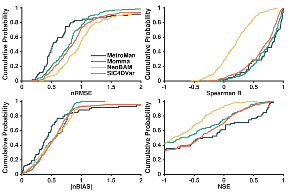
Fig. 9 Cumulative Distribution of Performance Metrics for SWOT Discharge Estimates vs. Gauges by Unconstrained FLPE Algorithm for Europe.
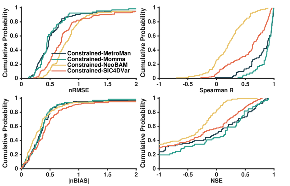
Fig. 10 Cumulative Distribution of Performance Metrics for SWOT Discharge Estimates (vs. Gauges) by Constrained FLPE Algorithm in Europe
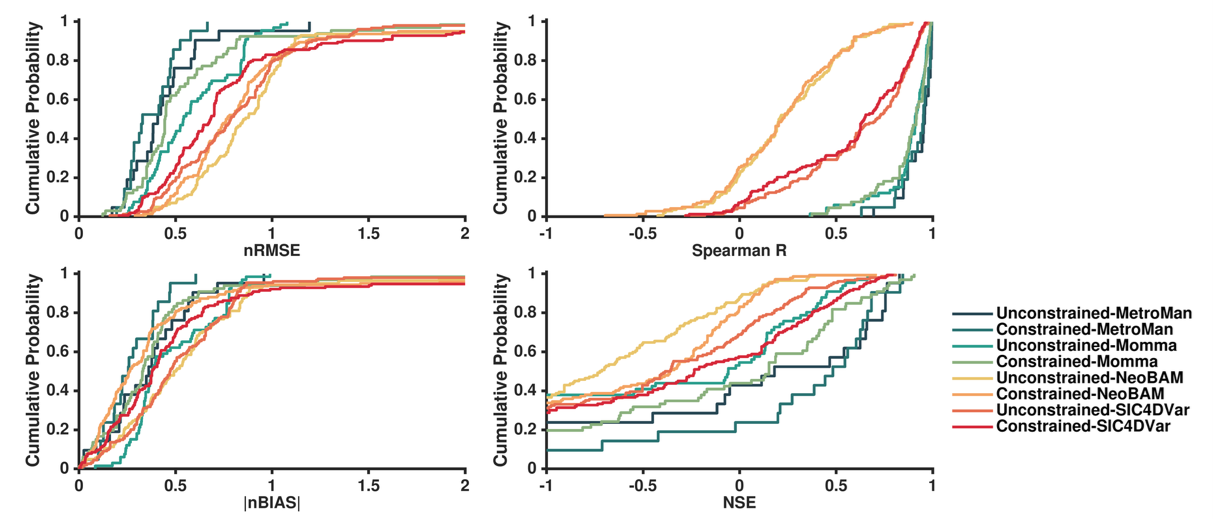
Fig.11 Cumulative Distribution of Performance Metrics for SWOT Discharge Estimates (vs. Gauges) by Unconstrained and Constrained FLPE Algorithm in Europe.
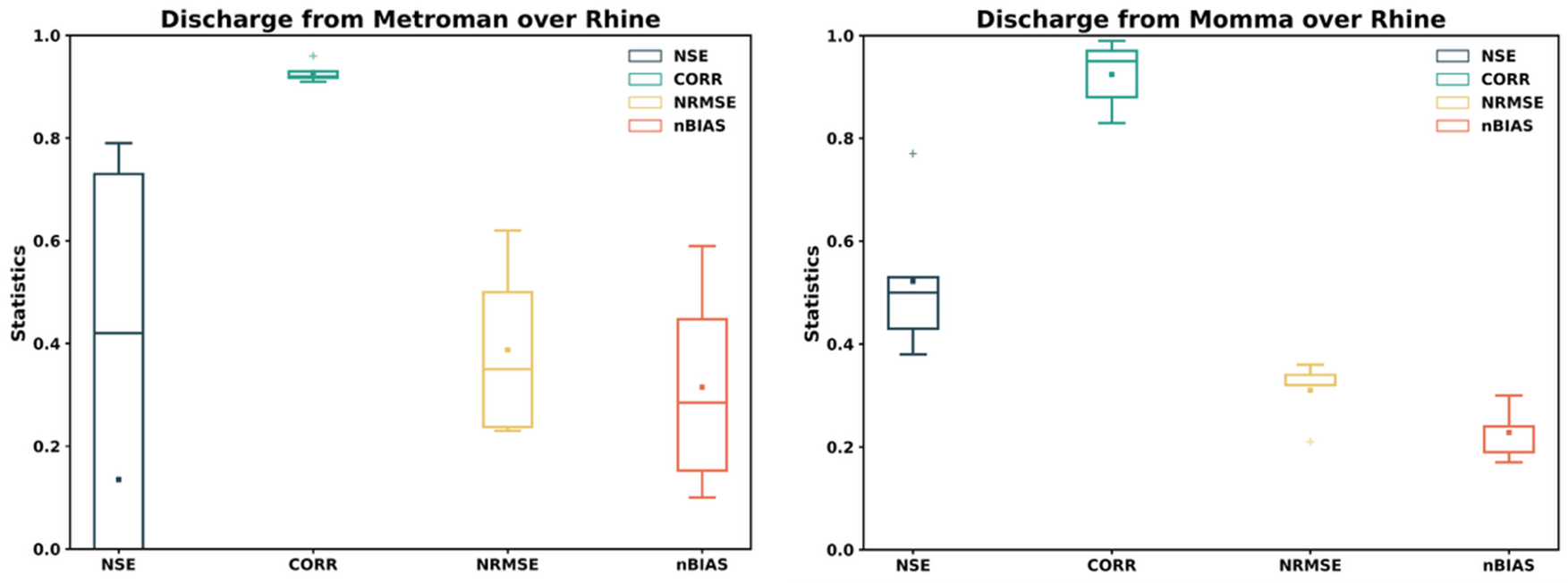
Fig. 12 Statistics of validation of discharge from the unconstrained runs of four algorithms used in Confluence applied to off-nadir against discharge from in-situ gauges in Europe, the rivers are Rhine and Danube, the number of stations is 12.
Publications
Andreadis, K. M., Coss, S. P., Durand, M., Gleason, C. J., Simmons, T. T., Tebaldi, N., et al. included L. Fenoglio (2025). A First look at river discharge estimation from SWOT satellite observations. Geophysical Research Letters, 52, e2024GL114185. https://doi.org/10.1029/2024GL114185
Buchhaupt Ch., Egido A., Dinardo S., Maraldi C., Moreau T., Fenoglio, L. (2025). Impact of the Antenna Characteristics on Sea Surface Parameters Estimated from Low- and High-Resolution Satellite Altimetry, Advances in Space Research. https://doi.org/10.1016/j.asr.2025.02.056.
Chen, J., Fenoglio, L. and Kusche, J. (2025). Measuring off-nadir river water levels and slopes from altimeter fully-focused SAR mode. Journal of Hydrology, https://doi.org/10.1016/j.jhydrol.2024.132553.
Durand M. et al. included L. Fenoglio (2023) A framework for estimating global river discharge from the SWOT satellite mission, Water Resources Research, https://doi.org/10.1029/2021WR031614.
Fenoglio et al. (under review), High resolution river and estuarine water level topography from nadir altimetry
Fenoglio et al. (2025a), Water level and discharge variation from modern-era satellite altimetry (to be submitted by Oct 2025).
Fenoglio et al. (2025b), Validation of SWOT altimetry in the 200-km reach of the Rhine river (to be submitted by Oct 2025).
Fenoglio et al. (2025c), Monitoring surface water storage change in lake and reservoirs from SWOT and nadir-altimetry (to be submitted by Oct 2025).
Jaramillo et al. included L. Fenoglio (2024). The potential of hydrogeodesy to address water‐related and sustainability challenges. Water ResourcesResearch, doi:10.1029/2023WR037020
Srinivasan, M., et al. included L. Fenoglio (2025). Launching into societal benefits from the Surface Water and Ocean Topography (SWOT) mission. Water Resources Research, 61, e2024WR038436. https://doi.org/10.1029/2024WR038436
Wan, W., Guo, Z., Karegar, M. A., Tang, G., & Larson, K. M. (2025). GNSS hydrology: Defining a new interdiscipline integrating GNSS hydrogeodesy and remote sensing. The Innovation, 6(10). https://doi.org/10.1016/j.xinn.2025.100990
, , , & (2025). GNSS observations of the land uplift in South Africa: Implications for water mass loss. Journal of Geophysical Research: Solid Earth, 130, e2024JB030350. https://doi.org/10.1029/2024JB030350
Zakharova, E., Fenoglio-Marc, L., Nielsen, K., Thorne, P., Restano, M., & Benveniste, J. (2026). Exploring the potential of Sentinel-3 and Sentinel-6 SAR altimetry measurements for discharge estimation: Case studies from the Rhine and Po rivers. Journal of Hydrology, 670, 135211. https://doi.org/10.1016/j.jhydrol.2026.135211
Fenoglio, L., Chen, J., Vignudelli, S., Abileah, R., Zakharova, E., Restano, M., Benveniste, J., & Kusche, J. (2026). High resolution river and estuarine water level topography from nadir altimetry. Journal of Hydrology, 135681. https://doi.org/10.1016/j.jhydrol.2026.135681