B03
Deep learning for satellite-based land use and land cover reconstruction
Prof. Dr. Ribana Roscher
University of Bonn | +49 228 73-60854 |
Johannes Leonhardt (PhD student)
University of Bonn | +49 228 73-60841 |
Summary
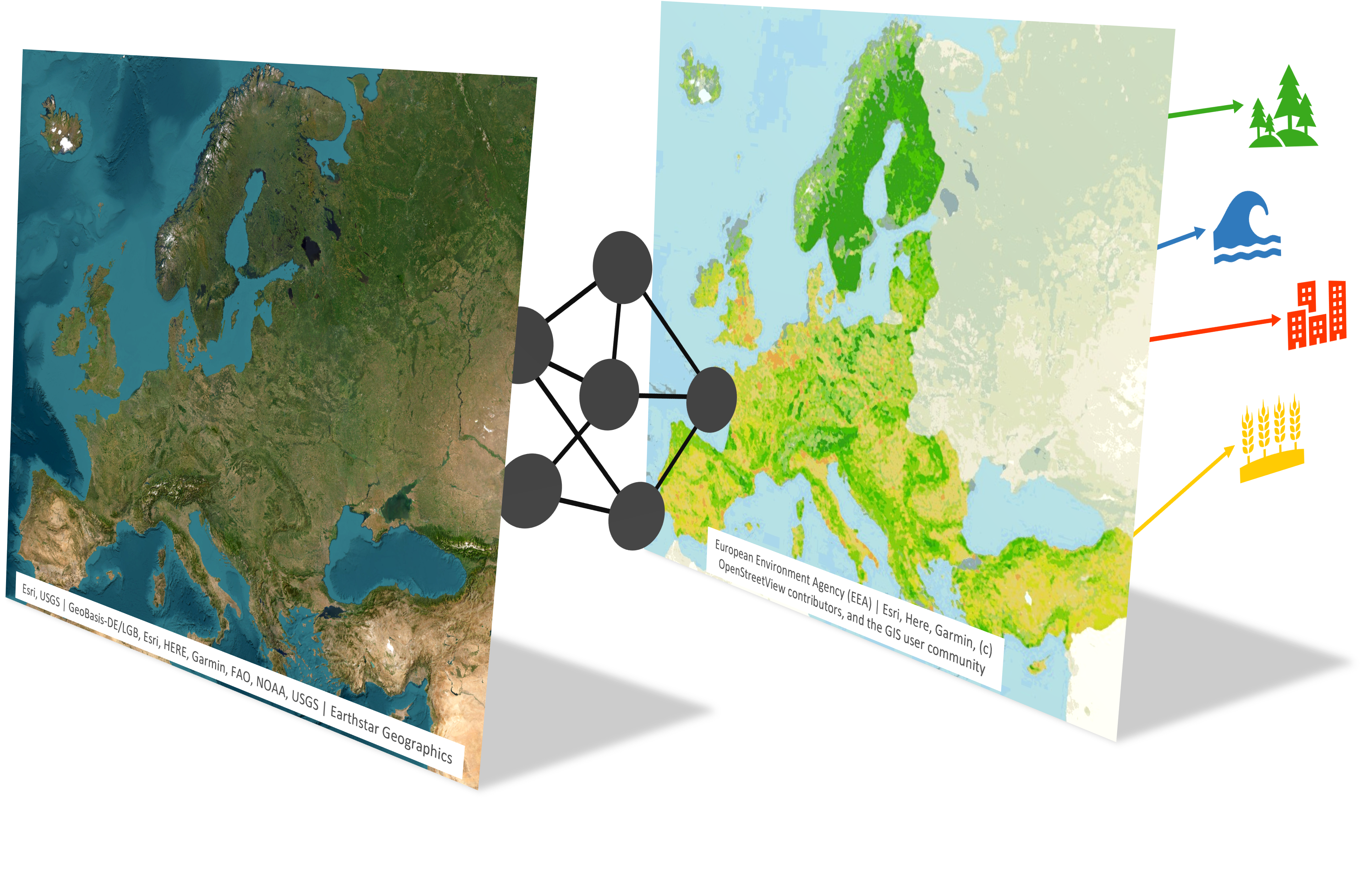
The goal of this project is the reconstruction of land use and land cover across Europe from optical satellite data using deep learning. To this end, we will develop spatio-temporal deep neural networks that consider the specific biogeographical characteristics of the regions of interest in order to ensure a high generalization capability across the study region. Furthermore, predictive uncertainties for the derived land use and land cover maps will be determined and the model’s capabilities in the context of multi-task learning will be explored. Finally, the potential of generated data for data augmentation purposes will be evaluated.
Graphical Summary
Contribution to CRC
Land use and land cover maps generated in our project will be reused by other projects in DETECT for a variety of purposes: On the one hand, the A and B clusters will rely on these data to determine relevant regions for their own purposes, such as agricultural or water areas. The C and D clusters, on the other hand, will use the maps as inputs for terrestrial models or for subsequent analyses.
Approach
To train our neural networks we will rely on openly available medium resolution, multispectral imagery from Sentinel-2 and the Landsat satellites. Observations from the Land use/cover area frame (LUCAS) surveys will be used as reference data. As those data are distributed rather sparsely, special methods for semi-supervised learning will be developed. Bioclimatic auxiliary information shall be incorporated into the workflows to improve generalizability. As for generative models models for data augmentation, we look to adapt state-of-the-art diffusion models from the computer vision community to the domain of multispectral satellite imagery.
Main results in 2022
- Creation of an extensive database for satellite data (Sentinel-2, Landsat 8), sparse labels for training deep learning models (LUCAS), and auxiliary information (WorldClim-BC).
- Conceptualization of the deep learning model for land cover classification from sparse label data using graph neural networks.
- Conceptualization of approaches for improving geographic generalizability of land cover classification models.
Main results in 2023
- Continued implementation of the graph neural network-based land cover classification model.
- Implementation and publication of a method for incorporating bioclimatic information into classification workflows using conditional normalization layers (Leonhardt et al., 2023).
Main results in 2024
- Publication of preliminary results from the graph neural network-based land cover classification model (Leonhardt & Roscher, 2024).
- Conceptualization and implementation of a diffusion-based generative model with an application to climate-aware data augmentation for improved land cover classification.
- Preparation of time-variable and consistent land cover and LAI datasets for usage in other DETECT subprojects.
Main results in 2025
- Publication of the generative diffusion autoencoder model for climate-aware satellite image editing (Leonhardt et al., 2025).
- Conceptualization of Landsat-to-Sentinel translation methods for extending the model application timeframe.
Publications
- Leonhardt, J., Drees, L., Jung, P., & Roscher, R. (2022). Probabilistic biomass estimation with conditional generative adversarial networks. In DAGM German Conference on Pattern Recognition (pp. 479-494).
- Leonhardt, J, Drees, L., Gall, J., & Roscher, R. (2023). Leveraging bioclimatic context for supervised and self-supervised land cover classification. In DAGM German Conference on Pattern Recognition (pp. 227-242).
- Stomberg, T. T., Leonhardt, J., Weber, I., & Roscher, R. (2023). Recognizing protected and anthropogenic patterns in landscapes using interpretable machine learning and satellite imagery. Frontiers in Artificial Intelligence, 6, 1278118.
- Leonhardt, J. & Roscher, R. (2024). Sparsely labeled land cover classification with oversegmentation-based Graph U-Nets. In ICLR Machine Learning for Remote Sensing Workshop (ML4RS).
- Drees, L., Demie, D. T., Paul, M. R., Leonhardt, J., Seidel, S. J., Döring, T. F., & Roscher, R. (2024). Data-driven crop growth simulation on time-varying generated images using multi-conditional generative adversarial networks. Plant Methods, 20(1), 93.
- Leonhardt, J., Gall, J., & Roscher, R. (2025). ClimSat — A diffusion autoencoder model for climate-conditional satellite image editing. Science of Remote Sensing, 100235.
-
Farag, M., Emam, A., Leonhardt, J., & Roscher, R. (2025). Enhancing decision support in crop production: Analyzing conformal prediction for uncertainty quantification. Computers and Electronics in Agriculture, 237, 110559. https://doi.org/10.1016/j.compag.2025.110559