D07
Mass fluxes and budgets at catchment and continental scales
Prof. Dr. Jürgen Kusche
University of Bonn | +49 228 73-2629 |
Dr. Benjamin Gutknecht (PostDoc)
University of Bonn | +49 228 73-60586 |
Summary
In project D07, we analyse terrestrial/atmospheric and surface water fluxes and associated budget contributions from model simulations, reanalyses and remote sensing observations for large river basins in Europe. Modelling results are combined with catchment-integrating observations like GRACE/-FO derived water storage variability and river discharge. We inter-compare budget components from the CRC’s modelling system and validate against external observations and reanalyses. The project quantifies to what extent regional changes of land and water use contribute to observed budget changes. It can also, e.g., derive new basin-scale estimates for mean evaporation and inter-annual variability, and quantify the terrestrial-atmospheric contribution of the modelling region to sea level budgets.
Graphical summary
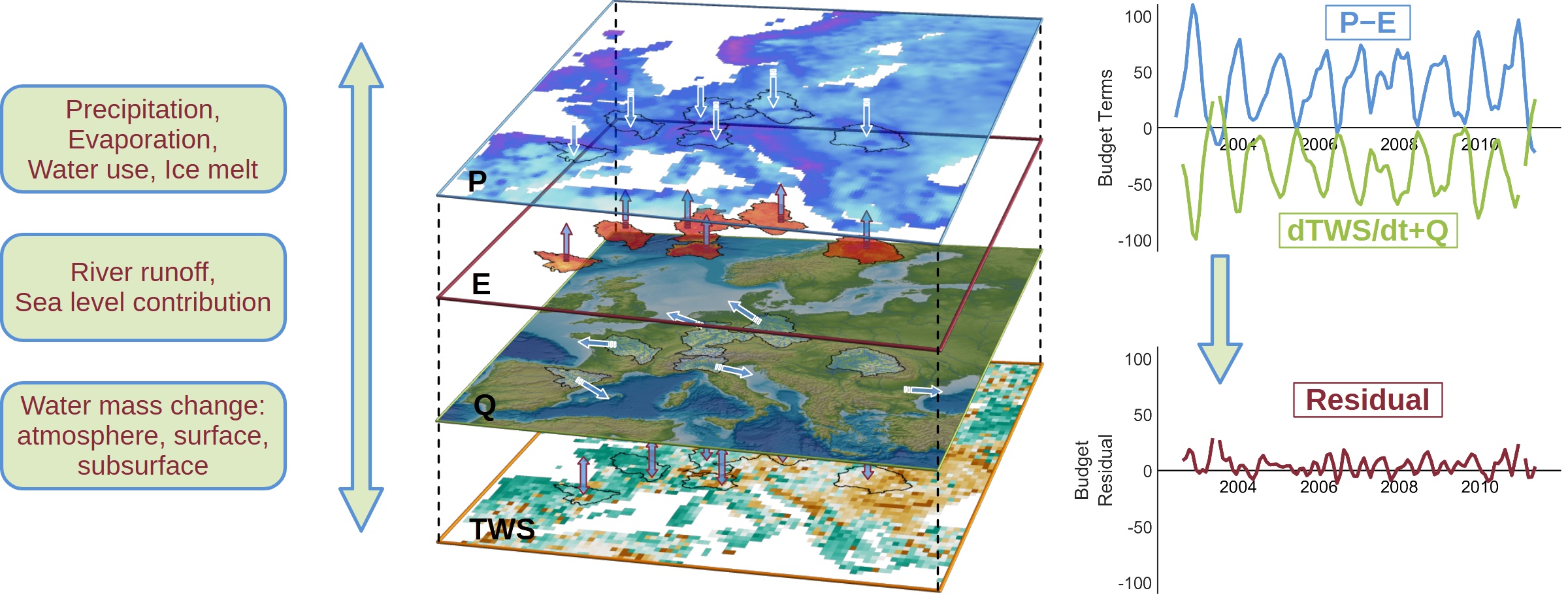
Figure 1. Continental water budgets: In this example, mass net flux (P−E) from precipitation (P) and evaporation (E) across the surface boundary is balanced by river runoff (Q) and the change in terrestrial water storage (TWS). The upper right panel shows time-series (2002—2011) for both terms of the water balance equation for the Rhine catchment in mm per month: basin-averaged P−E net flux derived from ERA5 reanalysis (blue), compared with observed river run-off at the Rees river gauge in combination with the change in water storage (green). Analyses of budget residuals (lower right) allow us to identify systematic offsets in data sets and to validate DETECT’s earth system model scenarios.
Contribution to the CRC
Our main contribution to the CRC is a systematic integrated analysis of components of the terrestrial water budget (Figure 1). This provides an evaluation of the modelling results obtained in the CRC, while at the same time it enables us to estimate unobserved components as budget residuals and thus study their variability in response to natural and anthropogenic forcing. One major asset is our expertise in GRACE/-FO satellite gravimetry post-processing and evaluation, i.e. we provide tempo-spatial observations of gravity changes, which can be interpreted as total integrated water mass change over the assessed region. On a technical level, we assist the CRC with geospatial vector data of rivers and their catchment areas, and we organize cross-cluster consistent use of GRDC river discharge data in close collaboration with several other projects. D07 also post-processes high-resolution DETECT model products for consistent use with observation data sets.
Approach
For deriving terrestrial water mass change (dTWS/dt), we primarily use spherical harmonic coefficients of unconstrained gravity models of GRACE/-FO satellite observations, analysed at basin-scale. We compare this total change to the integrated sum of observed and modelled in- and out-flux of water masses such as precipitation (P), evapo(transpi)ration (E) or river run-off (Q). In this way, we are able to identify biases in contributions by a weighted combination with the remaining components and dynamically feed this information back to involved partner projects. Furthermore, we identify long-term trends and changes in water-budget terms from decadal time series.
Main Results in 2022 - 2025
(1) Validation of P-E net fluxes from the D02 SST experiment
We performed an evaluation of modelled precipitation and evaporation from an ICON Regional Climate Model (RCM) by DETECT project D02 by means of continental water budgets (Lopes et al., 2026). The ICON RCM experiment tested the impact of various sea surface temperature (SST) forcings on modelled water fluxes while the rest of the model setup was kept identical. D07 evaluated the resulting (modelled) P-E net fluxes against observed monthly river discharge and terrestrial water storage change over various European primary catchments for 2002—2011.
We found that P-E of all ICON RCM runs in general fit better with observed streamflow and storage change compared to ERA5 reanalysis, which showed a few millimetres ‘wet’ bias (see Figure 2). During summer months, RCM P-E fluxes appear to overestimate net losses compared to GRACE-derived water storage change and GRDC river discharge combined.
While differences between RCM fluxes on monthly catchment scale remained comparably small on continental and long-term average, we found that the slightly colder ‘skin’ type SST systematically leads to slightly ‘dryer’ conditions. However, these differences are so small that it is challenging to determine a significant ‘best-fit’ SST type. It should be noted at this point that monthly- and regionally-averaged data do not necessarily catch short extreme events: think of a brief but intense >>50 mm rain-induced flood during a drought, which could mathematically still result in a ‘dry’ phase when averaged and miss to indicate differences in peak precipitation.
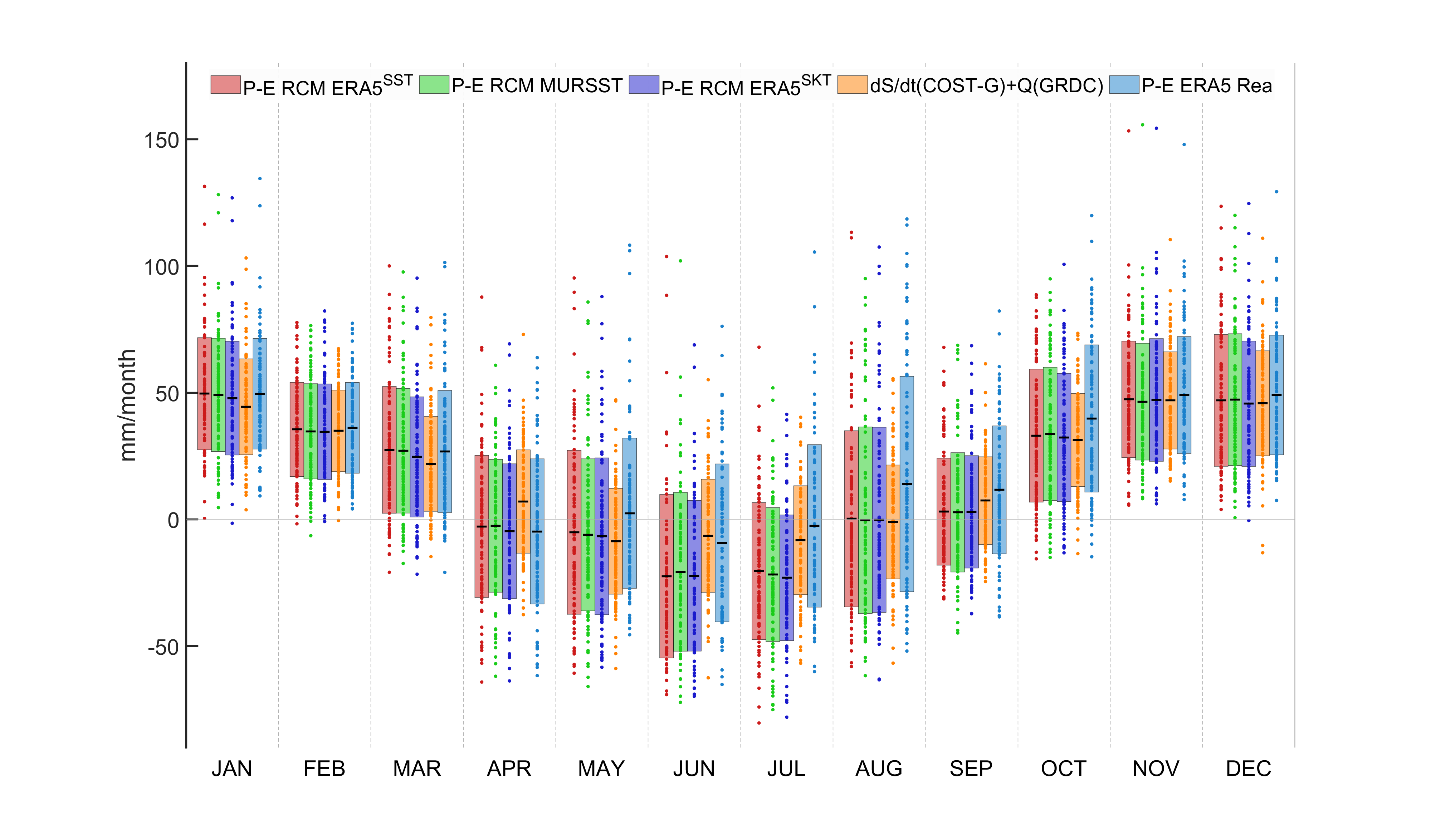
Figure 2. 2002—2011 multi-annual monthly continental water balance P-E net flux terms from the ICON RCM SST experiment (RGB-colours) and ERA5 reanalysis (light blue) in comparison with observed TWS change plus river discharge (orange) over all 12 analysed catchment kernels combined. Boxes indicate the ±1σ range over all the years and catchments; black dashes represent the mean. Note the relative wet-bias of ERA5 reanalysis and how the slightly colder SKT SST in the ICON RCM leads to a small but systematic lower net flux towards the ground.
(2) Evaluation of reconstructed long-term TWS data sets
From DETECT C03 reconstructed terrestrial water storage 1984—2020 (Hacker et al., 2026) , we estimated monthly total evaporation using the continental water budget equation solved for total evaporation (Figure 3). Solely GRACE-based approaches of this kind for TWS are normally restricted to start 2002-Apr at the earliest, but this DETECT dataset gave us the opportunity to estimate catchment averaged monthly time-series of total evaporation from the surface starting in the 1980ies.
Evaluation of our data shows general good agreement with GLEAM (Miralles et al., 2011) total evaporation in several selected river basins around the globe. But it also reveals that evaporative fluxes were to be significantly higher during peak precipitation months if the water balance condition has to be fulfilled. Long-term trend analysis furthermore show a change in basin-average characteristics, e.g. more evaporation over the upper Niger catchment in response to increased precipitation. While over the Amazon region, an increasing share of river discharge in the total loss-fluxes indicates that we observe an effect of changes in land-cover that favours more run-off over interception and transpiration.
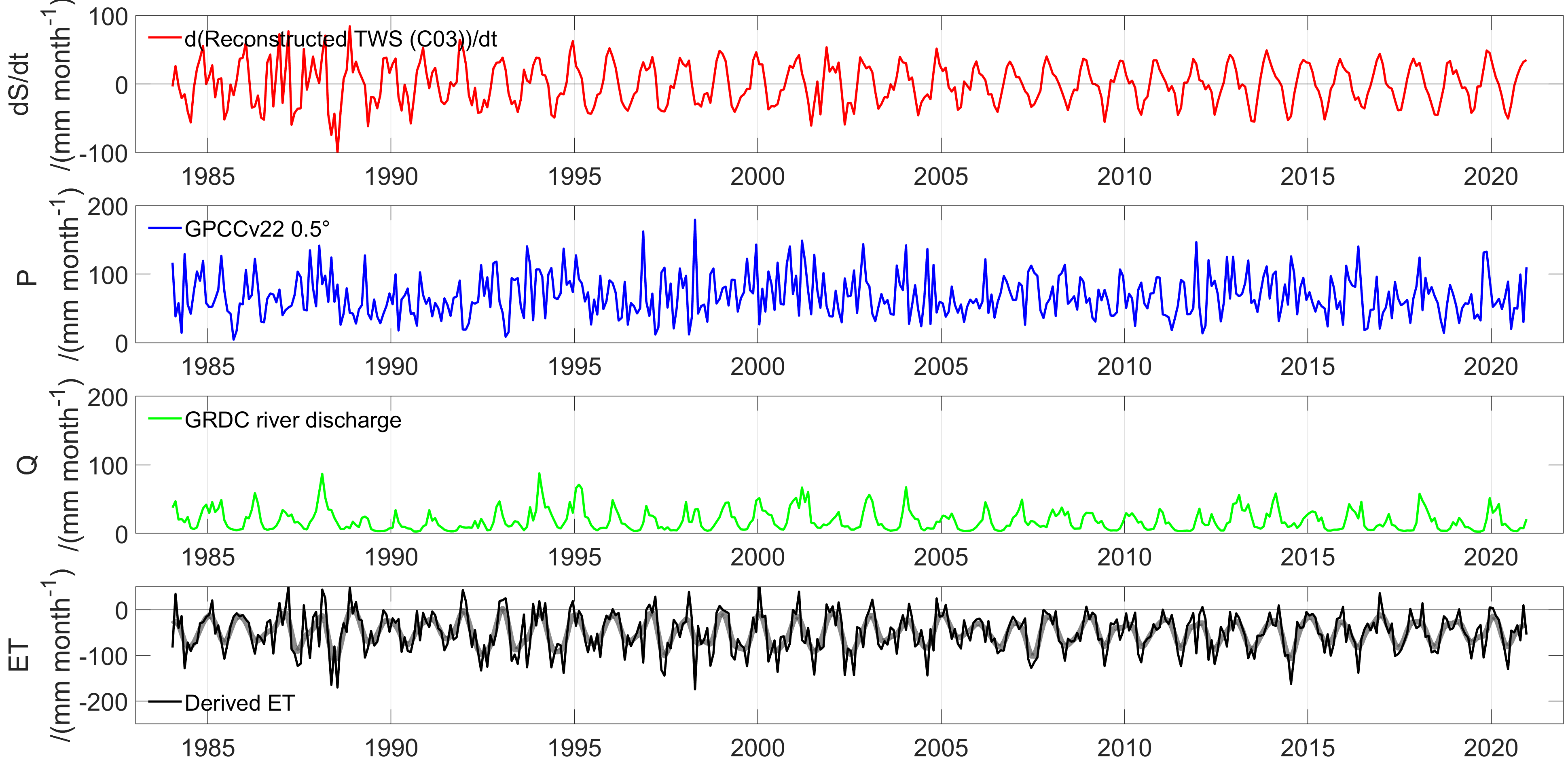
Figure 3. Monthly resolved time-series of continental water budget components over the Loire catchment (France). From top to bottom: (1) terrestrial water storage change as derived from the DETECT C03 reconstruction; (2) Precipitation from GPCC; (3) River discharge at Montjean station from GRDC, Koblenz; (4) Total Evaporation as derived from DETECT C03 data via budgets using GPCC and GRDC (solid black), and its 3-month filtered version (thick grey curve).
(3) Evaluation of external reference data and DETECT model output variables (including human water use)
DETECT project D07 evaluated an ensemble of water-cycle related variables from external and DETECT internal data products. In this example, spanning the last two decades, we have analysed monthly accumulated total precipitation averaged over the Danube catchment, which involved eight DETECT-internal scenarios from three projects like the D02 SST experiment, or anthropogenic (human) water use model runs by D02 (TSMP) and D03 (ICON).
We find that uncorrected E-OBS shows a systematic relative dry-bias, ERA5 reanalysis is among the wettest products, while the GPCC gridded monthly product at 0.25° resolution shows a more moderate-to-low average precipitation (Figure 4). ICON with irrigation and TSMP with human water use (HWU) cases show a slight ‘wet’ tendency, which indicates an intensified water cycle when compared to control runs without water use enabled. When analysed over the whole EURO-CORDEX domain, notable regional differences occur between individual basins, but the large Danube catchment shown here is representative for the general large-scale behaviour.
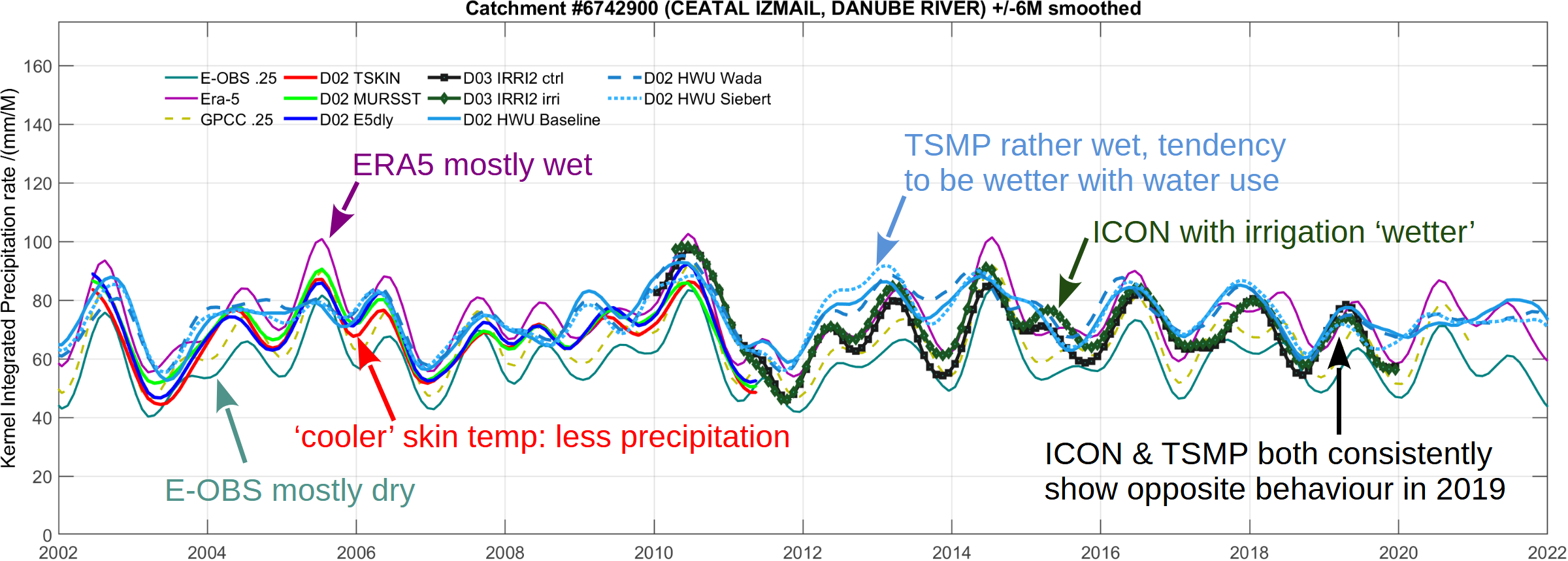
Figure 4. Time-series of monthly accumulated precipitation averaged over the Danube catchment (Ceatal Izmail station) for a selection of 11 different products. For external reference: E-OBS, GPCC and ERA5, and from within DETECT: 3xD02 ICON SST experiment, 3x D02 TSMP Anthropogenic Water Use (HWU) scenarios, and 2x D03 ICON Irrigation experiment. A 6-month Gaussian smoother was applied for visual accentuation.
DETECT Atmospheric Variables Inter-comparison
D07 co-organises and participates in a DETECT cluster-wide inter-comparison of essential water-cycle related model variables, such as precipitation, 2-metre temperature, total evaporation or heat fluxes. We post-processed external reference data sets and a selection of DETECT model outputs to ensure consistent inter-comparison and provided areal definitions for integrated analyses. This ongoing assessment is aimed to be a comprehensive overview of the variety of TSMP- and ICON model setups in DETECT and includes results from the inclusion of anthropogenic water use compared to control runs.
Published Datasets:
- Gutknecht, B. (2025). Catchment-Averaged Monthly Evaporation Timeseries 1984--2020 Derived from GRACE-like TWS Change via Terrestrial Water Budgets (1.0.0) [Data set]. Zenodo. https://doi.org/10.5281/zenodo.16643628
- Gutknecht, B., Kusche, J., & Lopes, F. (2025). Catchment-Averaged Monthly Water Budget Net Flux Timeseries 2002--2011 from ICON v2.6.4 Simulations, GRACE TWS, and GRDC Discharge over the EURO-CORDEX Domain (1.0.0) [Data set]. Zenodo. https://doi.org/10.5281/zenodo.17954263
Publications:
- Li, F., Springer, A., Kusche, J., Gutknecht, B. D., & Ewerdwalbesloh, Y. (2025). Reanalysis and forecasting of total water storage and hydrological states by combining machine learning with CLM model simulations and GRACE data assimilation. Water Resources Research, 61, e2024WR037926. https://doi.org/10.1029/2024WR037926
- Kusche J. et al. (2025). Benefit of MAGIC and multipair quantum satellite gravity missions in Earth science applications, Geophysical Journal International, 242(2) ggaf195, https://doi.org/10.1093/gji/ggaf195
- Lopes, F. d. S., M. Schindelegger, B. Gutknecht, and J. Kusche, 2026: Dynamically Downscaled European Water Budget Quantities in the Presence of Sea Surface Temperature Uncertainty. J. Hydrometeor., 27, 129–149, https://doi.org/10.1175/JHM-D-25-0018.1.
- Li, X., Kusche, J., Jin, T., Zhong, Y., Gutknecht, B. D. (submitted 2025-09-05). Advancing the Budyko framework performance for monthly evapotranspiration estimation using a hybrid approach.
- Li, X., Jin, T., Kusche, J., Gutknecht, B.D., Xiao, M., Hacker, C., Li, F. (2025). Unveiling the ~three-year oscillation in terrestrial water storage change: detection and attribution analysis. Preprint available at: ESS Open Archive. September 25, 2025. https://doi.org/10.22541/essoar.175883417.71192619/v1
- Roque, J. L., Lopes, F. d. S., Giles, J.A., Gutknecht, B. D., Schalge, B., Zhang, Y., Ferro, M., Friederichs, P., Goergen, K., Poll, S., Valmassoi, A. (2025). Intercomparison of a High-Resolution Regional Climate Model Ensemble for Catchment-Scale Water Cycle Processes under Human Influence. Preprint available at Arxiv (2025-11-05): https://doi.org/10.48550/arXiv.2511.02799
-
, , , & (2025). GRACE-FO and future satellite gravity missions will need to account for global cloud water convergence. Journal of Geophysical Research: Atmospheres, 130, e2025JD044124. https://doi.org/10.1029/2025JD044124
- Y. Zhong, Y. Wang, J. Kusche, B. Tian and Y. Wu, "A Novel Metric for Quantifying Precipitation-Driven Variability in Global Terrestrial Water Storage," in IEEE Transactions on Geoscience and Remote Sensing, vol. 64, pp. 1-14, 2026, Art no. 4201314, doi: https://doi.org/10.1109/TGRS.2026.3650800.
- Hacker, C., Gutknecht, B. D., Löcher, A., and Kusche, J.: Multidecadal reconstruction of terrestrial water storage changes by combining pre-GRACE satellite observations and climate data, Earth Syst. Sci. Data, 18, 1747–1781, https://doi.org/10.5194/essd-18-1747-2026, 2026.
- Li, F., & Kusche, J. (2026). Reproducing GRACE total water storage change at finer spatial scales. Geophysical Research Letters, 53, e2025GL119881. https://doi.org/10.1029/2025GL119881
- Springer, A., De Lannoy, G., Rodell, M., Ewerdwalbesloh, Y., Gerdener, H., Khaki, M., Li, B., Li, F., Schumacher, M., Tangdamrongsub, N., Tourian, M. J., Nie, W., and Kusche, J.: A review of current best practices and future directions in assimilating GRACE/-FO terrestrial water storage data into numerical models, Hydrol. Earth Syst. Sci., 30, 985–1022, https://doi.org/10.5194/hess-30-985-2026, 2026.
- Li, F., & Kusche, J. (2026). Observation-driven forecast of global terrestrial water storage and evaluation for 2010–2024. Water Resources Research, 62, e2025WR041710. https://doi.org/10.1029/2025WR041710
Conference Presentations:
- Gutknecht, B. D., Springer, A., and Kusche, J. (2023): Water Mass Fluxes and Budgets at Catchment-Scale over Europe in the Collaborative Research Cluster 'DETECT', EGU General Assembly 2023, Vienna, Austria, 23–28 Apr 2023, EGU23-9933, https://doi.org/10.5194/egusphere-egu23-9933, 2023.
- Gutknecht, B. D., Springer, A., Kusche, J. (2023): Water mass fluxes and budgets at catchment-scale over Europe in the Collaborative Research Centre SFB 1502 DETECT. 28th General Assembly of the International Union of Geodesy and Geophysics (IUGG), 11—20 July 2023, Berlin, Germany, IUGG23-4753, JG-05.
- Gutknecht, B. D., Kusche, J., Lopes, F., Roque Mamani, J, Zhang, Y. (2025): Observation-Based Evaluation of Anthropogenic Land- and Water-Use Scenarios in Regional Water Budgets over Europe. ESA Living Planet Symposium 2025, 23—27 June 2025, Vienna, Austria, 3944, A.07.08.
Outreach and more:
- We regularly represent DETECT with water-cycle related topics during outreach events such as “Girls’ & Boys’ Day”, “Tag der Geodäsie”, “Science Rally”, or at State-level Geodesy field days.
- We provide expertise in close collaboration with our institute’s superconducting gravimeter lab to derive long-term series of regional water storage change.